PhD project at DTU Environment
The PhD work was part of the research project REMTEC - (REMediation and Assessment TEChnologies for contaminated soil and groundwater) that was mainly dealing with DNAPL contaminants in quaternary sediments. The project wass conducted at the Danish Technical University (DTU) and the Geological Survey of Denmark and Greenland (GEUS).
The PhD topic scattered around the hydrogeological characterization of glacial sediments in Denmark. Detailed descriptions of the geology including heterogeneity at finest scale are necessary to enable solute transport modeling for potential pollutants and remediating agents at contaminated sites. I tried to classify geological heterogeneity, respectively sand lenses, by means of field observations and borehole logs and simulated the spatial distribution with geostatistical tools. In the final analysis, we developed a numerical model for contaminant transport accounting for simulated small-scale preferential flow networks.
PhD thesis for download (pdf)Risk assessment of contaminant transport
The migration of contaminants in the subsurface is critical for groundwater resources. Valid transport models for porous or fractured media are an ongoing research topic to quantify risks and to predict breakthrough of contaminant plumes.
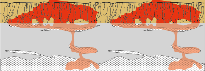
Study outline: One aspect of the REMTEC project aimed to model the transport of chlorinated solvents at contaminated sites. At a specific site in Denmark, the geology, source zone and groundwater levels are well-known from previous investigations. The geology comprises low-permeability tills and we used different geological scenarios to mimic heterogeneity. In particular, fractures and sand lenses are expected to create preferential flow paths in the subsurface. An equivalent porous medium (EPM) served as reference, and subsequently we added complexity to the medium incorporating different stochastic realizations of heterogeneity.
Results: It was shown that sand lens networks, if connected, can significantly enhance the horizontal migration of pollutants as well as accelerate the growth of the contaminant plume. A critical parameter here is the connection between fractures in the uppermost soil horizons and sand lenses below. For risk assessment of contaminated sites it is recommended to include geological heterogeneity at its best, since it affects the transport pattern and possibly enhances the risk of contamination in more distant groundwater wells.
Publications:
Kessler, T.C., Chambon, J.C., Binning, P.J., Nilsson, B., Klint, K.E., Bjerg, P.L.: Implications of Sand Lenses for Solute Transport in Heterogeneous Clayey Tills, Scientific Paper, in review.
Kessler, T.C. (2012). Hydrogeological characterization of low-permeability clayey tills - the role of sand lenses. PhD thesis, DTU Environment, Kgs. Lyngby, Denmark. 62 pages (pdf).
Geostatistics and mutiple-point statistics
Geostatistics are used to analyse spatial variability and to simulate the distribution of, for example, geological variables. Multiple-point statistics emerged as an advanced algorithm that uses training images to learn and simulate specific structural patterns.
Study outline: Sand lenses in tills have complex shapes and high spatial variability. Vertial till outcrops allow mapping of sand lenses and generating digital, two-dimensional training images. We used multiple-point and transition probability-based statistics to parameterize the images and to simulate sand lenses. The main objective was to use one training image and to simulate another unsampled reference image. In addition, we compared the two different approaches in terms of geometry, shape and numbers of reproduced features.
Results: The study showed enhanced capabilities of multiple-point approaches to reproduce non-stationary training images and curvilinear shapes that are typical for sand lenses. A three-dimensional block realization of simulated sand lens distributions illustrates a possible preferential flow network in clayey tills.
Publications:
Kessler, T.C., A. Comunian, F. Oriani, P. Renard, B. Nilsson, K.E. Klint, and P.L. Bjerg (2012). Modeling fine-scale geological heterogeneity - examples of sand lenses in tills. Groundwater.
Kessler, T.C., K.E. Klint, P. Renard, B. Nilsson, and P.L. Bjerg (2010). Geostatistical description of geological heterogeneity in clayey till as input for improved characterization of contaminated sites. IAHS, GQ2010, Proceedings paper.
Kessler, T.C. (2012). Hydrogeological characterization of low-permeability clayey tills - the role of sand lenses. PhD thesis, DTU Environment, Kgs. Lyngby, Denmark. 62 pages (pdf).
Quaternary geology
Study description: Clayey tills are riddled with sand lenses of various size. Depending on the deposition regime of the till and the subsequent deformation processes, those sand lenses can have complex, multiple anisotropic shapes (Fig 6). We collected field data from numerous till outcrops following a systematic methodology and defining a set of geometric parameters. These parameters were used to derive a simple classification scheme for sand lenses in tills. The scheme can be used as a tool for future till investigations and support the genetic interpretation of tills. In other words, the deformation style recorded in the geometry of sand lenses is a novel criterion to identify till types and to study palaeoglaciological conditions.
Publications:
Kessler, T.C., K.E. Klint, B. Nilsson, and P.L. Bjerg (2012). Characterization of sand lenses embedded in tills. Quaternary Science Reviews, 53, 55-71.
Kessler, T.C., K.E. Klint, B. Nilsson, and P.L. Bjerg (2011). Characterization of sand lenses and their role for subsurface transport in low-permeability clay tills. GeoHydro 2011, Proceedings paper.
Kessler, T.C. (2012). Hydrogeological characterization of low-permeability clayey tills - the role of sand lenses. PhD thesis, DTU Environment, Kgs. Lyngby, Denmark. 62 pages (pdf).


